 cam2amip2
 and
OBS data
cam2amip2
and
OBS data
DIAG Set 3 - Line plots of DJF, JJA and ANN zonal means
| Willmott & Matsuura 1950-99 | DJF | JJA | ANN | |
|---|---|---|---|---|
| TREFHT * | 2-meter air temperature (land) | plot | plot | plot |
| Legates & Willmott 1920-80 | DJF | JJA | ANN | |
| PRECT * | Precipitation rate | plot | plot | plot |
| TREFHT * | 2-meter air temperature | plot | plot | plot |
| NCEP Reanalysis 1979-98 | DJF | JJA | ANN | |
| FLUT * | TOA upward longwave flux | plot | plot | plot |
| FSNTOA * | TOA net shortwave flux | plot | plot | plot |
| FSNTOAC * | TOA clearsky net shortwave flux | plot | plot | plot |
| LWCF * | TOA songwave cloud forcing | plot | plot | plot |
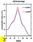
| PREH2O * | Total precipitable water | plot | plot | plot |
| PSL * | Sea level pressure | plot | plot | plot |
| SWCF * | TOA shortwave cloud forcing | plot | plot | plot |
| TS * | Surface temperature | plot | plot | plot |
| ECMWF Reanalysis 1979-93 | DJF | JJA | ANN | |
| PREH2O * | Precipitable water | plot | plot | plot |
| ECMWF Reanalysis 1985-88 | DJF | JJA | ANN | |
| FLDS | Longwave downwelling surface flux | plot | plot | plot |
| FSDS | Shortwave downwelling surface flux | plot | plot | plot |
| NVAP 1988-1997 | DJF | JJA | ANN | |
| PREH2O * | Total precipitable water | plot | plot | plot |
| TGCLDLWP | Cloud liquid water (ocean) | plot | plot | plot |
| GPCP 1979-2000 | DJF | JJA | ANN | |
| PRECT * | Precipitation rate | plot | plot | plot |
| CMAP (Xie-Arkin) 1979-98 | DJF | JJA | ANN | |
| PRECT * | Precipitation rate | plot | plot | plot |
| SSM/I (Wentz) 1987-2000 | DJF | JJA | ANN | |
| PRECT * | Precipitation rate (ocean) | plot | plot | plot |
| PREH2O * | Total precipitable water (ocean) | plot | plot | plot |
| TGCLDLWP | Cloud liquid water (ocean) | plot | plot | plot |
| TRMM (3B-43) 1998-2001 | DJF | JJA | ANN | |
| PRECT * | Precipitation rate | plot | plot | plot |
| ERBE Feb1985-Apr1989 | DJF | JJA | ANN | |
| FLUT * | TOA upward longwave flux | plot | plot | plot |
| FLUTC * | TOA clearsky upward longwave flux | plot | plot | plot |
| FSNTOA * | TOA net shortwave flux | plot | plot | plot |
| FSNTOAC * | TOA clearsky net shortwave flux | plot | plot | plot |
| LWCF * | TOA longwave cloud forcing | plot | plot | plot |
| SWCF * | TOA shortwave cloud forcing | plot | plot | plot |
| ISCCP Jul1983-Dec1999 | DJF | JJA | ANN | |
| CLDHGH | High cloud cover | plot | plot | plot |
| CLDLOW | Low cloud cover | plot | plot | plot |
| CLDMED | Mid cloud cover | plot | plot | plot |
| CLDTOT * | Total cloud cover | plot | plot | plot |
| Warren Cloud SOBS | DJF | JJA | ANN | |
| CLDLOW | Low cloud cover | plot | plot | plot |
| CLDTOT * | Total cloud cover | plot | plot | plot |